We arrived home on Saturday, October 15, 2011. We were delayed for four days at Savannah due to high winds and rain, then made good time after departing the Isle of Hope Marina on Tuesday, October 11th.
Here's the itinerary since arriving in Oriental, North Carolina, on September 30th.
We stayed in Oriental, ICW mile180.8, an extra day until October 2nd, 2011, waiting for higher-than-comfortable wind to lay down on Bogue Sound which runs about 25 miles from Beaufort/Morehead City to Swansboro. After departing on October 2nd we stopped for fuel at Jarretts Bay Boat Works on the way to Morehead City, then continued on through Bogue Sound (the wind was decent) to Mile Hammock Bay at Camp Lejeune, North Carolina, where we anchored for the night.
The next day we were underway by 0650 and after almost 10 hours underway (45 minutes or so waiting for various bridges to open) we had gone down Cape Fear River and were tied to the free dock at the Provision Company at Southport, North Carolina. Remind us never to stop there again - the food is very poor - we can't figure out why anyone comes from any distance to eat there!
On October 4th we departed at 0710 and anchored for the night in the Wacama River anchorage at ICW mile 375, just off the Wacama River.
Over the next several daysWe stopped for the night at Graham Creek (north of Charleston) at mile 439, then at the Seabrook anchorage at Fenwick Island at mile 512, and on the night of October 7th at the Isle of Hope Marina just east of Savannah, Georgia, at mile 584. Druing the day on the 7th we read repeated weather forecasts, all predicting stormy weather for the next several days and boats were discussing what they were going to do while the storm passed. Since we had stopped at the marina in order to get fuel and spend the night, we arranged to stay several more days while the storm passed. By the end of the next day (October 8th) the marina was totally full and had boats tied to the fuel dock (a spot normally kept open for boats needing to get fuel). For the next three days we had high winds and torrential rain (one boat clocked some gusts at 55 mph).
By October 10th the wind and rain had subsided, and the forecast was decent for the next day, so on Tuesday, the 11th of October we departed at 0920 (had to wait for the tidal current to subside a bit) and started laying tracks to get home as soon as we could. We anchored that night in the North River at mile 652, then on October 12th we crossed into Florida and a few hours later anchored at South Amelia River at mile 725.8.
October 13th took us through St. Augustine and then because there are no good anchorages for a number of miles we stopped for the night at the newly opened marina at Marineland. What a nice facility it is! We've gone by there by boat and car for a number of years and always wondered why no one had opened a marina in the nicely protected basin just off the ICW. Well, this August someone did, and it is a great, if remote, facility. Just across the road is the dolphin research center which reopened 4-5 years ago after being abandoned for a few years. The Georgia Aquarium is involved in the education center, and kayak tours of the surrounding area are operating out of the marina. Right across route A1A is a series of beautiful beaches. Nice place to stop!
Statistics for the trip at this point:
676hours 15 minutes underway; 3848.5 nautical miles/4422.2 statute miles
We departed Marineland Marina as soon as we could see the surface of the water on October 14th at 0700 and cruised the longest distance we made on any day of our trip: 89.9 statute miles in 12 hours and 30 minutes. We anchored after sunset just south of the NASA Causeway Bridge south of Titusville, Florida, at mile 885.
On Friday, October 15, 2011 we were underway at a leisurely 0810 and at 1210 we were back in our slip at Manatee Cove Marina at Patrick Air Force Base.
Trip: 702H45M 4013.6NM/4611.9SM based on the onboard GPS.
Total engine hours: 730
Fuel consumed (approximately): 1100 gallons
These past six months have been great and the cruise was fantastic.

Our northern cruise in 2011 to the Erie Canal, Lake Ontario and the Thousand Islands, the Rideau Canal, Ottawa, Montreal, Sorel and Lake Champlain.
Monday, October 17, 2011
Saturday, October 1, 2011
Oriental, North Carolina - October 1, 2011
September 23, 2011 Baltimore. We met Jennifer for dinner and enjoyed hearing of her experiences teaching in the Baltimore City school system. She's teaching geometry to 10th & 11th graders through a program that encouraged college grads from other disciplines to enter the teaching profession and provided concentrated training throughout the summer to prepare them for jobs in inner-city schools. She says it is more difficult than being a Division Officer on a Navy ship!
We departed Baltimore at 0655 on September 24th and headed straight down Chesapeake Bay after transiting the Baltimore channel to the Bay Bridge north of Annapolis. We arrived in Solomons and took a mooring at Zahniser's Marina at 1825, before sunset.
We had contemplated traveling all the way to Hampton, Virginia (just north of Norfolk) in one day so that the next morning Judy could get to a pharmacy to have some photos taken for a visa (more about that later), but it is a long trip and if the tidal current isn't just right, we'd get there after dark (something we prefer not to do). So we cut the distance in half and made it a two day trip. On the 25th of September (Sunday) we cast off the mooring at 0815 and anchored in Jackson Creek off the Piankatank River at 1705 for a day of 8 hours and 50 minutes. On Monday the 26th we were underway at 0805 and were at the Hampton Public Dock at 1515. Judy immediately went in search of a place that could take some passport-type photos for the visa she needs, but the best she could find was a small drug store where she could print some photos from pictures we had taken earlier. There wasn't time to get to a post office, so that was delayed for another stop.
One of the reasons we're hurrying back to Florida is that Judy was given the opportunity to travel to Tanzania, Africa, as part of a team teaching an instructor course for the American Heart Association. She is required to get a visa plus some immunizations prior to her departure on October 22nd, so the visa application had to get sent to the Tanzanian embassy in Washington, DC, as soon as possible, and passport-type photos were required to accompany the application.
On Tuesday the 27th we departed Hampton at 0715 heading for the Dismal Swamp Canal. This leg took us past the U.S. Navy base at Norfolk with it's long rows of every type of warship imaginable, then through the commercial areas with their container ships and loading facilities, through downtown Norfolk and the USS Wisconsin display, and finally through the industrial areas south of Norfolk in the area of Chesapeake, Virginia.
After the Gilmerton Bridge we departed the "standard" ICW and headed toward the Dismal Swamp Canal and the "secondary" ICW route into Albermarle Sound. We had only a short wait for the lock at Deep Creek, and after locking through stopped at a small dock for a short time to get a few grocery items and look for a post office where Judy's visa application could be mailed. The post office was 4-5 miles away, too far to walk, so we continued on through the 22 mile stretch of the canal between locks to South Mills bridge where we missed the 1600 opening by 15 minutes. We tied up to the bridge's approach wall for the night, and found a post office about two blocks away where Judy placed her visa application in the outgoing mail drop!
The next morning (Wednesday, Sept 28th) we went through the South Mills bridge and lock and were in the Pasquotank River heading for Elizabeth City and Albermarle Sound by 0905. The river current was favorable all the way past Elizabeth City (about 20 miles from the South Mills Lock) and into Albermarle Sound. Weather was good with light wind from the south, so we continued through the sound and into the Alligator River. Shortly after passing through the Alligator River bridge, about 4 miles from the mouth of the river, the wind speed started to increase slightly, the waves started showing a few white-caps, and clouds started building in the west. After checking several weather sources and radar images online it was apparent that we were in for some thunderstorms and heavy rain, and NOAA started broadcasting severe weather alerts for the area to the north of us. As we approached the part of the river that turns west, the rain started and we decided we would not turn to the west and head toward some of the storms, but would find a place to anchor on the western shore which would provide some protection from the westerly winds and the rain which began to rapidly increase. Judy prepared the anchor to deploy without her assistance and we closed up the topside steering area to provide protection from the wind and rain. We used the GPS and radar to guide us into a good anchorage just south of the ICW, and lowered the anchor with the bow pointing into the wind. We watched the radar and GPS for 30 minutes or so as the wind and rain continued and then gradually subsided. In another half an hour all was quiet and the storms had passed out of the area. We had a quiet dinner and everything was calm for the rest of the night.
Our travel for the next two days (Thursday and Friday) was dictated by Judy's need to complete a Webinar presented by her Legal Nurse Consulting organization in Orlando (and which she had worked on during the summer). We originally had planned to travel as far as the Pungo River the next day and anchor near a marina in Bellhaven which had a WiFi that we could pay for so that Judy could be assured of a good internet connection. That would have resulted in one short cruising day on Thursday and staying anchored near the WiFi for the day on Friday.
On Thursday, September 29th, we suddenly realized that we could get as far as Oriental, North Carolina in one long day and find an available WiFi there, so at 0850 we got underway from the Alligator River and arrived in Oriental, anchoring in Smith Creek at 1920 just as twilight faded. The next morning, Friday, we moved two miles to the Oriental Marina which had assured Judy that their WiFi was working well where we spent the remainder of the day and Judy completed the Webinar. As we were eating dinner that evening at the restaurant associated with the marina we became aware of a major change in the weather forecast which was for wind up to 25 mph from the northwest the following day for the area west of Beaufort, North Carolina, where we would need to travel. It is a stretch of water without much protection, and any wind in excess of 15 mph can create rough conditions. Temperatures were also forecast to drop into the 60s during the day. Consequently, we decided to stay another day in Oriental and the easiest place to stay was to remain at the Oriental Marina. We have walked to the only grocery store to buy fresh fruit and a few other items and now beef stew is simmering in the crockpot filling the boat with mouth-watering aroma!
Tomorrow the wind is forecast to subside a bit, so we'll depart Oriental and hope to get to Mile Hammock Bay at Camp LeJeune Marine Corps base past Swansboro, North Carolina. We'll stop for about 140 gallons of fuel on the way before we get to Beaufort/Morehead City.
We departed Baltimore at 0655 on September 24th and headed straight down Chesapeake Bay after transiting the Baltimore channel to the Bay Bridge north of Annapolis. We arrived in Solomons and took a mooring at Zahniser's Marina at 1825, before sunset.
We had contemplated traveling all the way to Hampton, Virginia (just north of Norfolk) in one day so that the next morning Judy could get to a pharmacy to have some photos taken for a visa (more about that later), but it is a long trip and if the tidal current isn't just right, we'd get there after dark (something we prefer not to do). So we cut the distance in half and made it a two day trip. On the 25th of September (Sunday) we cast off the mooring at 0815 and anchored in Jackson Creek off the Piankatank River at 1705 for a day of 8 hours and 50 minutes. On Monday the 26th we were underway at 0805 and were at the Hampton Public Dock at 1515. Judy immediately went in search of a place that could take some passport-type photos for the visa she needs, but the best she could find was a small drug store where she could print some photos from pictures we had taken earlier. There wasn't time to get to a post office, so that was delayed for another stop.
One of the reasons we're hurrying back to Florida is that Judy was given the opportunity to travel to Tanzania, Africa, as part of a team teaching an instructor course for the American Heart Association. She is required to get a visa plus some immunizations prior to her departure on October 22nd, so the visa application had to get sent to the Tanzanian embassy in Washington, DC, as soon as possible, and passport-type photos were required to accompany the application.
 |
| HUGE dredge working on the channel at Norfol |
 |
| Entering lock at Deep Creek, Dismal Swamp Canal |
 | |
| Mileage from the lock |
After the Gilmerton Bridge we departed the "standard" ICW and headed toward the Dismal Swamp Canal and the "secondary" ICW route into Albermarle Sound. We had only a short wait for the lock at Deep Creek, and after locking through stopped at a small dock for a short time to get a few grocery items and look for a post office where Judy's visa application could be mailed. The post office was 4-5 miles away, too far to walk, so we continued on through the 22 mile stretch of the canal between locks to South Mills bridge where we missed the 1600 opening by 15 minutes. We tied up to the bridge's approach wall for the night, and found a post office about two blocks away where Judy placed her visa application in the outgoing mail drop!
 |
| Waiting from bridge at South Mills |
 |
| South Mills Lock entry into the Pasquotank River |
Our travel for the next two days (Thursday and Friday) was dictated by Judy's need to complete a Webinar presented by her Legal Nurse Consulting organization in Orlando (and which she had worked on during the summer). We originally had planned to travel as far as the Pungo River the next day and anchor near a marina in Bellhaven which had a WiFi that we could pay for so that Judy could be assured of a good internet connection. That would have resulted in one short cruising day on Thursday and staying anchored near the WiFi for the day on Friday.
On Thursday, September 29th, we suddenly realized that we could get as far as Oriental, North Carolina in one long day and find an available WiFi there, so at 0850 we got underway from the Alligator River and arrived in Oriental, anchoring in Smith Creek at 1920 just as twilight faded. The next morning, Friday, we moved two miles to the Oriental Marina which had assured Judy that their WiFi was working well where we spent the remainder of the day and Judy completed the Webinar. As we were eating dinner that evening at the restaurant associated with the marina we became aware of a major change in the weather forecast which was for wind up to 25 mph from the northwest the following day for the area west of Beaufort, North Carolina, where we would need to travel. It is a stretch of water without much protection, and any wind in excess of 15 mph can create rough conditions. Temperatures were also forecast to drop into the 60s during the day. Consequently, we decided to stay another day in Oriental and the easiest place to stay was to remain at the Oriental Marina. We have walked to the only grocery store to buy fresh fruit and a few other items and now beef stew is simmering in the crockpot filling the boat with mouth-watering aroma!
Tomorrow the wind is forecast to subside a bit, so we'll depart Oriental and hope to get to Mile Hammock Bay at Camp LeJeune Marine Corps base past Swansboro, North Carolina. We'll stop for about 140 gallons of fuel on the way before we get to Beaufort/Morehead City.
Friday, September 23, 2011
Chesapeake Bay - September 23, 2011
Fast and brief. We stayed a night on the south wall at Champlain Canal lock #9 on September 12th, two nights at the yacht basin in Fort Edward (where I changed the engine oil and filters), then another two nights (due to weather) in Mechanicville at the free town dock (with electricity).
We departed Mechanicville on September 17, 2011, and haven't stopped for more than one night since.
Kingston, New York at the Kingston Municipal Marina on September 17th after exiting the Champlain Canal and passing through the Federal Lock at Troy.
Haverstraw Bay on the night of September 18th.
Great Kills (Staten Island) New York on September 19th where we had dinner with a good friend, Kevin.
Atlantic City, New Jersey, on September 20th where we were lucky enough to get a spot on the dock at Gardner's Basin after a 13 hour, 86 nautical mile day!
Cape May, New Jersey, at the anchorage, on September 21st.
We refueled on Thursday morning then departed Cape May on September 22nd and made it all the way into the Chesapeake where we anchored for the night in Veasey Cove on the Bohemia River just a few miles from the western end of the Chesapeake and Delaware Canal. Delaware Bay was as peaceful as it gets, and we saw the tall ship Danmark following and then passing us on its way up the bay heading to Philadelphia (we assume).
This morning we departed Veasey Cove and caught a fair tide down the upper Chesapeake to Baltimore where we're going to have dinner with Jennifer tonight (it's raining cats and dogs).
Tomorrow we'll head to Solomons and the next day to Norfolk. The weather is predicted to be good for those two legs - all except the 90% chance of rain both days.
Monday, September 12, 2011
Into the Champlain Canal - September 12, 2011
After two nights at Button Bay waiting for word about the Champlain Canal and when all the locks would be open, we departed on Sunday, September 11, 2011 heading south after learning that lock C-12 at Whitehall (the northern most lock at the south end of Lake Champlain) had opened for transit. Locks C-4 through C-1 (at the south end of the canal) remain closed. As the Notice To Mariners (NOTAMS) states it:
Mariners are advised that the Champlain Canal from Lock C-1 (Waterford) to Lock C-4 (Schagticoke/Hempstreet Park) remains closed due to high water levels until further notice.
The forecast included winds from the south gusting to 20 mph and with our full exposure to southerly winds in Button Bay, we wanted to find a place to anchor further south that would provide some protection. We identified a potential anchorage at Five Mile Point, but couldn't find any information about that location; nonetheless, we decided to give it a try after concluding that there weren't any other possible anchorages that provided protection from southerly winds. We left Button Bay at 1030, and at 1340 the anchor was down in about 9 feet of water just north of Five Mile Point on the west (New York) side of Lake Champlain. The wind subsided, never reaching 20 mph, and we spent a quiet night there.
This morning we departed Five Mile Point at 0735 in order to get the 30 miles to the start of the Champlain Canal around noon. Since the canal has some low bridges, we lowered the mast while underway and it now sits in a "crutch" on the back deck; with the mast down our "air draft" is a little less than 15 1/2 feet, so we will be able to clear all of the fixed bridges on the Champlain Canal. By 1200 we had exited lock C-12 at Whitehall and were in the Champlain Canal heading south. We stopped for the day at 1515 on the south west side of lock C-9, a nice, quiet spot in a park-like setting. We are the only boat on the long wall.
Weather tomorrow is forecast to be windy with the temperature in the high 70s. We have to do a little engine work to trouble-shoot an overheating issue that came up today, and then we'll move a little further south to lock C-7 and Fort Edward. A friend from Fort Edward, Fred Wehner (who has been helping a lot of boaters get through this area with all the flooding), drove up to see us tonight and to report that there should be plenty of room for us at the Fort Edward Yacht Basin.
Cruising to date: 477H50M - 2973.2 SM
Saturday, September 10, 2011
Button Bay - September 10, 2011
Judy arrived from Kansas after a long, frustrating day flying from Wichita to Boston via Dallas, only to find that Colgan Air (a contract airline for USAir and Continental) "couldn't find a crew" to fly from Boston Logan to Plattsburg on the evening of September 5th. Due to Colgan's poor reputation for flights in and out of Plattsburgh (we learned too late) she didn't want to take a chance that the first flight the next morning would have a crew and certainly didn't want to spend the night in the airport (after being told that USAir would not put her up in a hotel for the night). She rented a car from Hertz for a one-way dropoff in Plattsburgh and drove about 240 miles through the beautiful mountains of New Hampshire and Vermont heading northwest in rain and fog most of the way, took the ferry across Lake Champlain at Gordon Landing, and arrived (in rain) at the Plattsburgh Boat Basin about 0100 on the 6th! It was a terrible experience for her and a lesson for both of us: don't ever trust Colgan Air!
Since we had a rental car for the remainder of the day on Wednesday we did some major reprovisioning at Hannaford's (a great supermarket chain, BTW) and got Sanderling ready to depart the marina the next day.
We departed the Plattsburgh Boat Basin on Wednesday, September 7th and after pumping out the holding tanks arrived at Shelburne Shipyard about 1425 that same day. We had arranged with the shipyard to install a new shaft saver when we were at the yard several weeks earlier, and at 0745 on Thursday (September 8th) morning John came aboard with a new shaft saver and had it installed in short order. We then topped off the water tanks, took on 100 gallons of fuel, and departed at 1105 heading south on the lake.
We stopped for the day a few hours later at Mile Bay where we wanted to visit the Lake Champlain Maritime Museum (http://www.lcmm.org/). We took a mooring belonging to the Basin Harbor Club (a resort fronting on the next small bay to the south) http://www.basinharbor.com/. After getting the boat secured, we lowered the dinghy and tied to the small dock where the Lake Champlain Maritime Museum has some of its boats, walked up the hill to the museum to ask how to get to the Basin Harbor Club's dock master's office, then walked a mile or so to the office, paid our $20.00 for the night's use of the mooring, and went back to Sanderling for the rest of the day.
On Friday, September 9th, we went ashore again, this time to visit the Lake Champlain Maritime Museum. What a great place to learn about the history of Lake Champlain, the Revolutionary War and the War of 1812. The exhibits start with the history of the area with a major emphasis on the contact of cultures in 1609 and Samuel de Champlain "The Father of New France," a French navigator, cartographer, draughtsman, soldier, explorer, geographer, ethnologist, diplomat, and chronicler. He founded New France and Quebec City on July 3, 1608. There is an exhibit of the 1902 ice yacht Storm King and a collection of dugout and bark canoes, kayaks, rowing skiffs and other small watercraft; the story of the Revolutionary War in the Champlain Valley; an exhibit featuring steamboats, lighthouses, early powerboats, engines and outboard motors; a nautical archeology center where work is underway to preserve artifacts and the 300 shipwrecks in Lake Champlain; a blacksmith shop; an active youth boatbuilding and outdoor education program; and an exhibit of photographs taken by local amateur and professional photographers. One of the things we learned that impressed both of us is that Benedict Arnold wasn't just a traitor; he played a major role fighting for the revolutionaries in the war on Lake Champlain. After touring the LCMM we had a late lunch at the Red Mill Restaurant (part of the Basin Harbor Club) and then headed back to Sanderling.
(Pictures to follow)
We departed Mile Bay and the Lake Champlain Maritime Museum at 1505, September 9th. The NOAA weather forecast from Burlington, Vermont, predicted winds from the west gusting to 25 mph early the next morning and Mile Bay and our mooring were fully exposed to wind from any direction except the south and east. A very congenial fellow at the 1776 gunboat replica of Philadelphia II suggested several bays on the western shore of the lake, but when we checked them they were either too small and deep, or provided little protection. We ended up in the bay we had originally identified as a good spot, Button Bay, just south of Mile Bay on the eastern shore and fully protected from any northerly winds. As it turned out, the 25 mph gusts did not materialize (consistent with non-NOAA forecasts).
The lower locks and the northern-most lock of the Champlain Canal remain closed today due to high water (the lake level is still three feet above "normal"), so we're going to stay here in Button Bay for at least another day. No rain is forecast until next week, so perhaps the lake level will lower a bit and the canal can reopen to traffic. We'd like to get heading south, but for the time being we are unable to leave Lake Champlain. Not a bad place to be, but it's starting to get chilly up here in the north.
Friday, September 2, 2011
Plattsburgh Boat Basin - September 2, 2011
Wind is blowing 15-20 from the south today, almost as much as when we were anchored at Nichols Point last week. The marina, despite the breakwater which extends to the southern side, and Sanderling are rockin' and rollin' almost as much as our anchorage when we had 25-30 mph winds! At least I can get off the boat by walking along the docks that are rolling and pitching - sea legs are definitely required.
I've just uploaded to our Picasa web site a few photos I took of a catamaran that was damaged when tropical storm Irene passed over Vermont a few days ago. Our blog dated August 29th has some information about how we spent TS Irene at anchor. The photos were taken August 31st the day after we arrived at the marina.
Here's the link to the photos of the catamaran: http://tinyurl.com/3kb6lmx
The photos are the last 8 photos on the page (other photos are a mix from our current cruise).
The catamaran is a 42 foot Venezia with a beam of around 24 feet. She was on a mooring at the Plattsburgh Boat Basin when Irene blew through. People I talked with who witnessed the event said that a total of four boats (all sail) broke their mooring pendants and were blown onto the breakwater which protects the marina and the mooring field. Unfortunately, the breakwater does not provide wind protection from the north, and that is where the strongest winds came from during Irene's passing. I understand that the owner's pendant broke during the height of the storm, as occurred with two of the other boats that went adrift; on the 4th boat, the marina's pendant parted. A fifth boat pulled it's mooring (1500+ pound blocks of concrete) through the mooring field (carefully avoiding other moored boats) before the owner, who was aboard, cut the line and motored into a slip on the south side of the marina. A crew of marina personnel (there was a hurricane party taking place during the storm) went out in a small boat during the storm, pulled the floundering boats from the breakwater and got them into the marina.
The cat is still sitting where she was placed when removed from the water, and I haven't noticed any activity regarding removal of equipment or repairs.
The water level on Lake Champlain at Plattsburg has risen about 1.5 feet since Irene; all of that extra water is creating havoc throughout the region. There was little damage to boats in the marina itself, and minimal damage to the marina. Marina employees have been working the past couple of days to lengthen the chains holding each dock section in place; many sections were listing as a result of chain that was too short to permit the dock to float level at the surface with the increased water height.
Judy is currently in Kansas for her mother's 90th birthday and I'm here in Plattsburgh taking care of the cats and Sanderling. We'll start heading south after Judy returns early next week; hopefully the Champlain Canal will be open to the Hudson River by then.
Monday, August 29, 2011
Lake Champlain - August 29, 2011
When we departed Plattsburgh we went into a very well protected anchorage in Hibbard Bay (north side of The Gut) on Saturday about noon and worked to get the anchor set well in all the weeds. After two attempts and waiting several hours for it to work its way into the mud below the weeds, we felt it was well set. The 50 MPH gusts we experienced during Irene's passing proved us correct.

Here's a photo of the sunset on Saturday night before Irene's arrival:
By midnight last night the barometer had started to climb (reached a low of 28.9 inches from the high at 0700 yesterday morning of 29.5) and the base-line winds were dropping to about 20 (from a high of 27/28 during the peak). These figures are all based on our own barometers and wind gauge, so may not coincide with NOAA figures.
 This is how the handheld GPS looked after Tropical Storm Irene had passed. Notice how the "blob" creates an arc. This was scribed as the wind shifted from the NE to the N and finally to the NW as TS Irene passed by to the east of us. The arc is created almost exactly 150 feet from the location of the anchor!
This morning the sky is clear and the sun is shining. Three of the four other boats in the bay have already left; only a single small sailboat remains.
We'll stay here for the remainder of the day and tonight, then tomorrow (August 30th) we'll move to a marina at Plattsburgh where we have a reservation for a week while Judy flies to Kansas for her mother's 90th birthday.
 On Tuesday the 30th we weighed anchor and moved to the Plattsburgh Boat Basin where Sanderling, the cats, and Bob will stay for a week. Here's a photo of the anchor chain and weeds/grass as we raised anchor preparing to depart. It's not an easy task getting rid of all the vegetation which gets wrapped around and interwoven in the chain.
Next post: a 42 foot catamaran is damaged in the storm and is removed to dry land for repairs.

Here's a photo of the sunset on Saturday night before Irene's arrival:
By midnight last night the barometer had started to climb (reached a low of 28.9 inches from the high at 0700 yesterday morning of 29.5) and the base-line winds were dropping to about 20 (from a high of 27/28 during the peak). These figures are all based on our own barometers and wind gauge, so may not coincide with NOAA figures.

This morning the sky is clear and the sun is shining. Three of the four other boats in the bay have already left; only a single small sailboat remains.
We'll stay here for the remainder of the day and tonight, then tomorrow (August 30th) we'll move to a marina at Plattsburgh where we have a reservation for a week while Judy flies to Kansas for her mother's 90th birthday.
 On Tuesday the 30th we weighed anchor and moved to the Plattsburgh Boat Basin where Sanderling, the cats, and Bob will stay for a week. Here's a photo of the anchor chain and weeds/grass as we raised anchor preparing to depart. It's not an easy task getting rid of all the vegetation which gets wrapped around and interwoven in the chain.
Next post: a 42 foot catamaran is damaged in the storm and is removed to dry land for repairs.
Monday, August 22, 2011
Lake Champlain - August 24, 2011
We returned to the USA on Saturday, August 20th and anchored that night. On Sunday we cruised to Shelburne's Shipyard on the Vermont side of the lake just south of Burlington. This morning the yard fixed the problem that had been causing the noise under the hull; turned out to be a Spurs line cutter part that had come loose and fallen off. Had to remove the remaining parts of the Spurs and won't be able to replace them until we have the boat hauled again next spring. Also discovered another problem and Shelburne's is ordering the necessary part and will replace it before we leave the lake in a couple of weeks. In the process they realigned the engine and shaft.
All is going well. Tonight we're anchored in a small bay (along with a dozen other boats - mostly sail) in a small bay south of Shelburne Shipyard.
On Tuesday, August 23rd, we cruised a short distance north to Burlington to the temporary dock at the Boathouse Marina, went ashore for a short time to buy a few groceries and had lunch at the restaurant at the marina. We then departed and headed north past Plattsburgh to anchor in a small bay at Nichols Point on the Vermont side of the lake. We were planning on cruising southeast to Plattsburgh on Wednesday, the 24th where we had hoped to meet some relatives for a couple of days of cruising, but high winds on the lake (gusting to 30 MPH) forced us to turn around after about 30 minutes and return to the anchorage. The forecast for Thursday isn't any better; in fact, it may be worse with winds forecast to be gusting to 35 MPH. So our plans are on hold right now while we're sitting at anchor in this small bay along with 6-7 other boats, most of which came in this morning after we had already been out and turned around.
By Thursday night the winds are forecast to die down, so hopefully we will be able to meet up in Plattsburgh on Friday morning and still have a day of cruising this beautiful area.
Here are a few pictures from our time in the anchorage, showing:

This is the track laid down by our handheld GPS during the high winds from the south while we were in the anchorage. North is up. The lower "blob" shows how we moved back and forth, side to side, in the wind with 100 feet of scope out; when the winds were forecast to increase, we added an additional 50 feet of chain and our position moved 50 feet to the north, shown by the upper "blob." This photo was taken on the morning of the 25th of August.
Compare these tracks to the tracks on the same GPS when we were treated to tropical storm Irene's winds (in the next blog post).
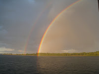 This beautiful double rainbow showed up evening of the 25th. It stretched from this location in the water, to directly alongside Sanderling on the other end of the rainbow. (We didn't even find a golden anchor.)
A short time later, we had this beautiful sunset, sailboat and all:
 On the 26th we crossed the lake to Plattsburgh where we met Caroline and Melissa at the town dock, after getting the holding tanks pumped out at the Plattsburgh Boat Basin. We crossed the lake, heading by the anchorage where we'd just spent the past several days, thru "The Gut" and then the draw bridge on the eastern side of The Gut, to St. Albans Bay where we spent the rest of the afternoon and evening talking and catching up on our families. Judy and I spent some time going over the charts looking for "hurricane holes" where we could wait out whatever Hurricane Irene was going to throw at us.
On the 27th, with Irene looming large on the horizon for the Lake Champlain valley and amid warnings from NOAA to prepare for near hurricane force winds, we motored back to Plattsburgh and said goodbye to Caroline and Melissa (they were driving to Chicago), and headed out to find a place that we felt would be safe from Irene's wrath.
We chose to motor back to The Gut and stay in a small area, Hibbard Bay, on its north side during Irene's passing. Turns out it was a good decision.
See our next post for more details on dealing with Irene.
All is going well. Tonight we're anchored in a small bay (along with a dozen other boats - mostly sail) in a small bay south of Shelburne Shipyard.
On Tuesday, August 23rd, we cruised a short distance north to Burlington to the temporary dock at the Boathouse Marina, went ashore for a short time to buy a few groceries and had lunch at the restaurant at the marina. We then departed and headed north past Plattsburgh to anchor in a small bay at Nichols Point on the Vermont side of the lake. We were planning on cruising southeast to Plattsburgh on Wednesday, the 24th where we had hoped to meet some relatives for a couple of days of cruising, but high winds on the lake (gusting to 30 MPH) forced us to turn around after about 30 minutes and return to the anchorage. The forecast for Thursday isn't any better; in fact, it may be worse with winds forecast to be gusting to 35 MPH. So our plans are on hold right now while we're sitting at anchor in this small bay along with 6-7 other boats, most of which came in this morning after we had already been out and turned around.
By Thursday night the winds are forecast to die down, so hopefully we will be able to meet up in Plattsburgh on Friday morning and still have a day of cruising this beautiful area.
Here are a few pictures from our time in the anchorage, showing:

This is the track laid down by our handheld GPS during the high winds from the south while we were in the anchorage. North is up. The lower "blob" shows how we moved back and forth, side to side, in the wind with 100 feet of scope out; when the winds were forecast to increase, we added an additional 50 feet of chain and our position moved 50 feet to the north, shown by the upper "blob." This photo was taken on the morning of the 25th of August.
Compare these tracks to the tracks on the same GPS when we were treated to tropical storm Irene's winds (in the next blog post).

A short time later, we had this beautiful sunset, sailboat and all:

On the 27th, with Irene looming large on the horizon for the Lake Champlain valley and amid warnings from NOAA to prepare for near hurricane force winds, we motored back to Plattsburgh and said goodbye to Caroline and Melissa (they were driving to Chicago), and headed out to find a place that we felt would be safe from Irene's wrath.
We chose to motor back to The Gut and stay in a small area, Hibbard Bay, on its north side during Irene's passing. Turns out it was a good decision.
See our next post for more details on dealing with Irene.
Monday, August 15, 2011
Sorel-Tracey August 15, 2011
After departing Montreal at 0955 on August 12, 2011, we headed downstream on the St. Lawrence River and anchored for the night off the main river channel at Contrecoeur - a nice, protected spot. About midway to Contrecoeur our Canadian SD data card for our Garmin chartplotter stopped loading the Canadian charts, so we relied on our navigation laptop and paper charts to guide us around the buoys and into the channel where we were anchoring. Nothing brought the Garmin Canadian charts back to life; something similar had happened several times in the past, but we were always able to get the charts to display after restarting the chartplotter. Fortunately, once we get down the Richelieu Canal north of Lake Champlain the pre-loaded charts will kick in again and we won't have to rely on the SD card charts.
 We departed the anchorage on August 13th and a couple of hours later were tied to a temporary dock at Marina de Sorel in Sorel-Tracey, near where the Richelieu Canal meets the St. Lawrence River. As we approached Sorel there were a number of large freighters anchored in the river, apparently waiting for pilots to come aboard to help them proceed upstream from Sorel. Since we've been in the marina, there have been freighters coming and going from the anchorages every day. We moved to our "permanent" transient dock about 1145 after Judy had picked up our rental car and the dock cleared of boats that were due to depart. Later in the day a beautiful 1933 power boat 65 feet in length came in and took the space in front of us; the boat was the Dolphin built here in Sorel and beautifully maintained.

 We rented a car in Sorel and spent Sunday (August 14th) in Quebec City. It's a beautiful place to visit, and we'll definitely have to come back to spend more time and see more of the sights. Basically we took two walking tours (around the Old City and through the Citadel) and walked by ourselves just to enjoy the ambience of the old city. The old city was very crowded with tourists. Restaurants were packed in the lower city (along the river), as well as just to the west of the city wall along a row of restaurants outside of the wall. Despite a forecast including 70% chance of rain, the temperature stayed in the mid-70s and the rain didn't materialize until our drive back to Sorel.
We decided to stay an extra day at the marina to do some laundry, turn in the rental car, buy more spider spray, and wait for sunny weather on Tuesday (August 16th) to start the trip south on the Richelieu. Spider spray? Have I mentioned that with all the docks we've been "moored" to this summer the boat is accumulating spiders faster than we can kill them! We've found that washing the boat doesn't really remove them (perhaps they hide somewhere out of the way of the wash), but spider spray does a good job of killing them. So, we needed more spray and Judy found some at the Canadian Tire store (really more like a Home Depot than a tire store) here in Sorel when she drove to turn in the rental car this morning.
Totals for cruise: 420H20M - 2627.0SM
 We departed the anchorage on August 13th and a couple of hours later were tied to a temporary dock at Marina de Sorel in Sorel-Tracey, near where the Richelieu Canal meets the St. Lawrence River. As we approached Sorel there were a number of large freighters anchored in the river, apparently waiting for pilots to come aboard to help them proceed upstream from Sorel. Since we've been in the marina, there have been freighters coming and going from the anchorages every day. We moved to our "permanent" transient dock about 1145 after Judy had picked up our rental car and the dock cleared of boats that were due to depart. Later in the day a beautiful 1933 power boat 65 feet in length came in and took the space in front of us; the boat was the Dolphin built here in Sorel and beautifully maintained.
 We rented a car in Sorel and spent Sunday (August 14th) in Quebec City. It's a beautiful place to visit, and we'll definitely have to come back to spend more time and see more of the sights. Basically we took two walking tours (around the Old City and through the Citadel) and walked by ourselves just to enjoy the ambience of the old city. The old city was very crowded with tourists. Restaurants were packed in the lower city (along the river), as well as just to the west of the city wall along a row of restaurants outside of the wall. Despite a forecast including 70% chance of rain, the temperature stayed in the mid-70s and the rain didn't materialize until our drive back to Sorel.
 We decided to stay an extra day at the marina to do some laundry, turn in the rental car, buy more spider spray, and wait for sunny weather on Tuesday (August 16th) to start the trip south on the Richelieu. Spider spray? Have I mentioned that with all the docks we've been "moored" to this summer the boat is accumulating spiders faster than we can kill them! We've found that washing the boat doesn't really remove them (perhaps they hide somewhere out of the way of the wash), but spider spray does a good job of killing them. So, we needed more spray and Judy found some at the Canadian Tire store (really more like a Home Depot than a tire store) here in Sorel when she drove to turn in the rental car this morning.
Totals for cruise: 420H20M - 2627.0SM
Wednesday, August 10, 2011
Montreal - August 8, 2011
We departed Bellevue at 0730 in order to allow most of the day for the passage through the St. Lawrence Seaway locks. We had been told that pleasure boats may have to wait up to 3-4 hours at each lock, and there was no option but to get to Montreal at the end of the 37 mile day!

 As it turned out, the passage through the first lock was delayed only by freighters passing through, one directly in front of us and others heading upstream which we passed before and after entering the first lock. The Great Lakes freighter John D. Leitch turned into the canal leading to the first lock just before us (coming down river) and had to slow considerably to permit to upbound freighters to pass in the straight stretches of the canal. After the John D. Leitch started to enter the lock, we tied up at the pleasure boat dock, bought our $25.00 pass for the first lock, and waited until the John D. Leitch cleared the lock going downstream and another freighter cleared heading upstream.
 By 1420 we were at the second lock and by 1610 we had completed the day's trip to the Port d'Escale Marina in Montreal. The last several miles were against the 6 MPH current on the St. Lawrence River after it had cascaded down the rapids we bypassed on the Seaway. Since we make only 7.3 MPH under the best of circumstances, we were making only 1.4 MPH over the ground heading to the marina. About 1/4 mile before the quay where the marina is located, we passed through the current and entered still water, then turned into the basin and into the marina. The staff spoke passable English (70% of the population in Montreal speaks French) and directed us to the dock where we would be located for the next few days; another young hand was on the dock to help us with our lines.
 Now we're sightseeing in Montreal, and a beautiful city it is. The first full day (August 9, 2011) we took the Metro to the Botanical Garden, and today we walked through the old city visiting the Archeological Museum, the Notre Dame Bassilica, and the Notre Dame chapel and a few other spots along the way. Tomorrow we're heading back out toward the Botanical Garden to visit the Olympic Stadium (1972) and Biosphere and inclined tower. A Canadian friend and his family are arriving by boat tomorrow and we're planning on dinner out with them tomorrow night before we depart on Friday heading to Sorell.


 As it turned out, the passage through the first lock was delayed only by freighters passing through, one directly in front of us and others heading upstream which we passed before and after entering the first lock. The Great Lakes freighter John D. Leitch turned into the canal leading to the first lock just before us (coming down river) and had to slow considerably to permit to upbound freighters to pass in the straight stretches of the canal. After the John D. Leitch started to enter the lock, we tied up at the pleasure boat dock, bought our $25.00 pass for the first lock, and waited until the John D. Leitch cleared the lock going downstream and another freighter cleared heading upstream.
 Now we're sightseeing in Montreal, and a beautiful city it is. The first full day (August 9, 2011) we took the Metro to the Botanical Garden, and today we walked through the old city visiting the Archeological Museum, the Notre Dame Bassilica, and the Notre Dame chapel and a few other spots along the way. Tomorrow we're heading back out toward the Botanical Garden to visit the Olympic Stadium (1972) and Biosphere and inclined tower. A Canadian friend and his family are arriving by boat tomorrow and we're planning on dinner out with them tomorrow night before we depart on Friday heading to Sorell.


Sunday, August 7, 2011
St. Anne de Bellevue - August 7, 2011
August 7, 2011
A quick post to bring you up to date since we departed Ottawa.
We tied to the lower wall at St A de Bellevue this morning after anchoring last night in a little bay just west of the lock. We departed Ottawa on Wednesday and after descending the eight locks into the Ottawa River anchored about 6 miles downstream at Little Duck Island. Thursday night we were in a small Marina at Montebello where we took on water for the first time in eight days (72 gallons) and did three loads of wash. On Friday we locked through Carillon Lock, the tallest lock in Canada with a 66 foot drop, then tied up for the night on their lower wall.


We will stay here for at least one night (when we look around today we'll decide whether to stay another day). When we leave here we will enter the St. Lawrence Seaway locks after about 6 miles and then be in Montreal at a marina the same day (about 35 miles total).

All is going well. We should be in Lake Champlain in another 10-12 days.
Monday, August 1, 2011
Ottawa - August 1, 2011
We departed Smith Falls at 0830 on Monday, July 25, and headed to Aylings Marina and Boatyard in Merrickville, arriving there about 1335. We were met at the Aylings by Doug who helped us secure our lines to a dock, then came aboard to talk about the problem we were having with the coolant loss. After some discussion, he went to work trying to figure out where the coolant was going. He soon eliminated the exhaust system (good news because that would have meant a leaking head or exhaust gasket and $$$ to replace), and eventually came to a leaking temperature control valve on the hot water heater. Some more checking and running the engine until it was hot confirmed that it was the valve. The installation manual indicated that a relacement valve would be required, but a call to the local dealer in Ottawa revealed that the valves were no longer being produced and were not available, so the only option would be to bypass the valve. By then it was late in the afternoon and Doug said he'd take care of it first thing in the morning. We ate dinner at a restaurant in Merrickville, and the next morning Doug came aboard to change the coolant lines around, we started the engine to get it up to operating temperature (no leak), shut down and let it cool off, and confirmed that the leak had stopped.
We filled the water tanks, Bob took a shower and we were off at 1320 heading toward Ottawa. We stopped at Burritts Lock in a beautiful setting for the night. The next day, July 27th, we departed Burritts Rapids Lock and five hours later stopped for the day at Long Island Lock - another beautiful spot. On Thursday, July 28th, we were underway at 1005 and cruised through a winding and sometimes narrow Rideau River until reaching Hartwell Lock, at which time we departed the Rideau River and entered a series of canals leading to Ottawa. The Rideau River is very much like the Erie Canal when it is following rivers past small towns, cottages, marinas and homes. Once we entered the canals we were in Ottawa proper, passing the University and other buildings following the man-made canal winding its way toward the Ottawa River. We stopped at "the wall" in Ottawa, about 400 yard short of the beginning of the eight stair-step locks that would lower us another 80 feet into the Ottawa River. The next morning many of the boats that had been on the wall when we arrived departed early, and we moved to the "head of the line" next to the tour boats that use the far west end of the newly refurbished wooden docks along the wall.
We are about 200 yards from the bridge over the street at Parliament Hill, with the National Arts Center to our port side. It's an active area, with a lot of boats tied to the wall and more boats coming and going up and down the flight of eight locks every few hours (it takes about 3 hours to pass through all the locks).
We have visited Parliament (you can take tours through the actual chambers), the Supreme Court building (tour given by a second year law student at the University), the National Art Gallery, and the Canadian Museum of Civilization, seen the sound and light show projected on the Parliament building, plus walked miles. This is a great spot to visit, with much to see and do.


We'll depart Ottawa on the 3rd (Wednesday) heading to Montreal where we anticipate arriving on the 8th or 9th.
More later!
Totals to date: 392H50M - 2435.6SM
Saturday, July 23, 2011
Smith Falls - July 23, 2011
July 14, 2011 (Thursday)
We were underway from the park at the dam at Upper Jones Falls about 1010 and by 1110 we had explored a couple of possible anchorages in Sand Lake and had the anchor down in West Bay. At the far end in about 15 feet of water with heavy grass for great holding. We have learned that lots of grass is our friend when anchoring, even if it does mean more work the next day. Several nice bays we've checked for anchoring have a flat stone bottom with no grass or gravel for holding. I was told by a local boater that grass doesn't grow in over 20 feet of water; it won't grow in any bottom without silt/sand/gravel, either. So now we look for bays less than 15 feet deep where we can see grass reaching toward the surface! We spent a quiet day here watching loons (and hearing their calls) and fishing boats of all sorts plying the shores.
July 15, 2011 (Friday) we moved 3.5 SM to upper Davis Lock. John the lockmaster seems to be a legend on the Rideau for his friendliness and helpfulness. He will let boats stay on the blue line, with hydro (Canadian speak for electricity) at $10 per night on the upper docks. He obliged us by putting us on the blue line (normally reserved for boats that want to lock through) immediately above the lock door on the starboard side, so we had a nice view of the lock and the boats going through it. There are a number of shorter docks in the little pond behind the lock which John created with his own initiative, so the first night there were a total of 17 boats of various sizes at the lock. The Canadian couple in the beautiful 1933 wooden boat (Dave and Liz) were on one of the docks at the back side of the pond and we had a nice reunion with them over the next several days. Most of the boaters there seem to know each other, and many have cottages on the nearby lakes and come to the lock on weekends. By the time we left on Sunday at noon many boats had departed.
We anchored on Sunday night (July 17) in Stouts Bay on Newboro Lake. Again, we confirmed the advantage of anchoring in grass. When we first entered the small bay there were several other boats anchored in various places at the winward end of the lake, so we anchored in an open area between them. The bottom looked rather desolate on the depth sounder, and later in the afternoon when we watched the other boats depart we saw that their anchors came up completely free of any grass; the bottom was a granite shelf. We then decided it would be best to find some grass or at least a better holding bottom, so moved to a shallower area between an island and shore where the depth sounder seemed to show some grass. We anchored there, putting out over 100 feet of chain in 15 feet of water, and later, after two storms passed through during the late evening and about 0130 in the morning, realized that we had, in fact, anchored in a good bed of lake grass; the anchor held through the storms without a problem.
From Stouts Bay we cruised 9.0 SM to the public docks at Westport, also on Newboro Lake. All docks are part of town marina operation and the price was quite reasonable with hydro. The little town had a good grocery store, three ice cream stores, bakeries, and several restaurants. We ate ashore both nights we were
there, shopped, ate ice cream, and Bob had freshly baked cinnamon buns both mornings for breakfast! We departed Westport on Wednesday, July 20 heading for Big Rideau Lake where we hoped to get a spot at the park docks on Colonel By Island (Colonel By is the man who supervised and was instrumental in the construction of the Rideau Waterway/Canal which was completed in 1832). When we approached Colonel By Island it was apparent that the dock was full, so we explored three other anchorages only to discover that one had very poor holding, one was narrow and over 25 feet deep even close to shore, and the third had little to no swinging room with a number of electrical lines laid on the bottom reaching the various small islands. So we cruised past Colonel By Island again (nothing had changed and there was nothing available on the dock), and ended up on the southern side of the lake not too far from Portland in a very nice little Bay - Sheldons Bay. The bottom was only 10 feet in depth with plenty of grass. We laid out 75 feet and never budged, even though the wind during the next day got up to 20 mph at times. The lake had several nice homes (not cottages) overlooking the water with small boats of various kinds at the docks. It looked like a nice place to live (or at least spend the summer months).
Portland had a marina with diesel fuel, the first we have found since departing Kingston. Our next destination was Smith Falls where we hoped to get a spot in the basin between the two locks. We got to the marina shortly after it opened at 0830 and took on 102 gallons of fuel (the first fuel we've taken on since Oswego, New York) in our starboard tank (we've been using the starboard tank only since we discovered a slight leak about 2/3rds of the way up on the port tank earlier in the trip), pumped out the forward holding tank, and by 0945 on the 22nd of July we were heading to Smith Falls where we were able to get the last dock with hydro available! During the day more boats arrived looking for space, and somehow managed to fill up the park walls and still find hydro in some of the places. This is the beginning of the "Construction Holiday" when the construction trades in Quebec take two weeks off so the workers can go on vacation. Everyone seems to have a boat, and every boat takes to the waterways. Many keep their boats in Montreal, so they come through the Rideau Waterway from both directions (from the north and Ottowa, and from the south and Kingston) making a circular route that includes the St. Lawrence River. The lock walls and parks are filled, and it is going to be difficult to find a place to stay for the next couple of weeks without going into a marina. We're a little concerned about whether we will be able to stay on the wall in Ottawa - we won't know until we get there.
We're staying here at least into Sunday (July 24th) and with the hot weather we're experiencing we may stay longer in order to have air conditioning on the boat at night. Smith Falls is a great location with much to do. Yesterday we toured the Rideau Canal Museum and today we went to the Canadian Railway Museum (learned what a "dental car" was) and the Heritage House Museum. This morning Bob got a hair cut (after three months he was looking a bit shaggy) and Judy says he looks better now! The "downtown" area is less than a block away with an ice cream shop, a number of restaurants, Rexall Drug store, and even a movie theater. The basin, the area between the locks, is surrounded by a nice park with lots of boats and RVs - people swimming in the relatively warm water, and just sitting out under the trees talking or reading. We've had several nice discussions with a Canadian couple who come here every summer for a few days from a town near Ottawa; we've gotten some good advice from them about places to stop as we approach Ottawa.

Bob is getting more concerned about the loss of coolant in the engine which he's been unable to resolve, so he's going to talk with a boat yard in Merrickville about checking the engine to determine the source of the leak and making a repair. If that occurs, we will stay in the yard/marina for at least several days while repairs are made. We're hoping it is something less serious than a head or exhaust gasket!
For those of you who may be interested in learning a little about the Rideau Waterway/Canal, the best source of info is at Rideau-info.com. The area certainly has an interesting history, and the whole thing started with the War of 1812!
The weather is really hot - 94 degrees each day for the past 3 days and there hasn't been much rain for a number of weeks. Today for the first time we turned on the air conditioning late in the afternoon so we, and Julie and Khepera, could get away from the heat. The forecast is for more of the same for the next 3-4 days.
We should be in Ottawa within a week, if all goes well with the engine repairs.
Totals to date: 368H45M - 2374.5SM
Monday, July 11, 2011
Jones Falls - Rideau Waterway
Judy returned from her quick trip to Syracuse where she dropped Andrew, Rebecca, Alyssa and Avery at the Amtrak station, did some shopping for items we wanted but cannot find in Canada (diet red mountain dew, for example), and returned, then we did the laundry (three loads). The next day (Saturday, July 9) we shopped for groceries in the morning while we still had a rental car, then toured the Maritime Museum and Pump House Museum in the afternoon.
July 10, 2011 found us departing the marina in Kingston for the Rideau Waterway and Ottawa. We cleared through the causeway bridge at 1100 and then proceeded north along the lower swampy area of the Rideau. When we encountered our first set of locks there were already some boats locking through so we tied up at the "blue line" along with two smaller boats who had followed us through the causeway. The crews of the smaller boats became our cruising friends through the next sets of locks and we had a good time together as we waited to lock through and then spent time in the locks themselves while we were lifted to higher levels. After the Upper Brewers lock they took off ahead of us at their much faster speed to make it to Jones Falls where they were going to spend the night.
We, on the other hand, stopped just short of Jones Falls in a spectacularly beautiful and small bay, Morton Bay, where we navigated through a very narrow opening to enter the bay, and then were presented with an incredible view of high granite cliffs surrounding the water. We anchored in about 15 feet of water near the western end of the bay about 1920, had leftovers for dinner, and turned in early after a long day. Just after anchoring we heard the loons calling, and one loon actually moved past Sanderling at about 25 yards while preening and calling. We also saw a wild turkey on shore, as well as a number of black squirrels. The night was quiet, as the high granite walls blocked any breeze that might have been blowing past.
This morning (July 11) while raising anchor and about 100 feet of chain, we had to deal with huge clumps of grass that had become entangled in the anchor line. We'd never seen anything like it, and Bob worried that if he didn't remove the grass as it came up on the chain the weight would be too much for the windlass eventually. So he raised the anchor 25 feet at a time then used the boat hook to remove as much grass as possible, then raised the next 25 feet, etc. As the anchor came out of the water there was a huge clump of grass wadded around the chain and the anchor, to the point that the anchor itself was barely visible. As Judy drove Sanderling back out through the narrow entrance, Bob worked to remove the remaining grass and get the anchor back up to it's stowed position on the bow.


Another 2 miles brought us to Kenney Inn and Marina at the lower side of Jones Falls locks where we were meeting a friend from Toronto, Georgs, for lunch. We tied to their dock and confirmed that it was OK to tie up for lunch. After a nice lunch and chatting with our friend who has traveled this area in his own boat, Georgs departed for some business in Picton and on to his home. Judy and I decided to remain on the dock for the night, so had an afternoon working on various projects and connected to WiFi from the hotel. Bob checked out some floating docks above the next flight of locks at Jones Falls, and talked to the lockmaster about locking up tomorrow morning in the first lift.

We'll start ascending the locks at Jones Falls about 0830 on July 12th, and hopefully an hour or so later we'll emerge in the lake above the four locks and find space on the floating docks near the dam which was built in the 1840s.
The Rideau is spectacular! Here is a link to more information about it and the surrounding area: Rideau Info
Friday, July 8, 2011
Kingston, Ontario
June 24, 2011 Grenadier Island Central Park
The previous day a number of smaller power boats descended on the docks taking most of the space. As soon as the boats tied up, out came portable gasoline generators which were taken to shore along with gasoline containers, and yellow extensions cords were laid from the generators to the boats so the occupants could run their air conditioners, laptops for the kids, lights, etc. The party started mid-afternoon, and although it broke for the rain storms that occurred in the evening, it began again when the rain stopped. Everyone was having a good time, except for those of us who wanted to get to sleep early! Understand this activity is rather typical for this time of year. French Canadians living in Quebec keep their small boats in Montreal, then all head out together for one of the islands for a couple of days of partying before heading back to Montreal and work.
We departed on the 24th and stopped around noon at Gananoque in the Municipal Marina. Had a great time looking around this small town, shopping for a few necessities at a food store, and eating out. Having four people to help carry groceries means we can buy more in one trip. The English Pub had been touted as THE place to eat in town, but we found it just so-so! Had a chance to do laundry in a real washer and dryer.
Bob was able to get some good advice about anchorages between here and Trenton/Belleville from a trawler owner who was docked in front of us and had cruised by sail and power for over 30 years. We took advantage of his advice over the next week while we headed west.
On the 26th of June we left Gananoque via a very scenic route along a narrow channel through some of the small islands heading toward Kingston. Around noon we anchored for the remainder of the day at Milton Island, just a few miles east of Kingston. The next morning we headed to Kingston and wanted to tie up at either of the two park docks on Cedar Island (the entire island is a park) but when we cruised past the northern dock it was being worked on by the park service, and the western dock was occupied by several boats. We went a bit further and anchored in Navy Bay, just to the east of Canada's military academy. Andrew and Avery took the dinghy back to Cedar Island to do some swimming, and after about 10 minutes reported to us via the VHF radio that the main dock on the west side was open.
Judy and I got underway, and while Andrew and Avery held a spot for us on the island dock, we motored over and took the only spot where Sanderling would fit. A few hours later another boat came in and took the smaller dock space, and toward evening a third small boat came in and took the inner side of the dock we were on. Beautiful island. That night we were visited, twice, by a raccoon. Judy scared it away the first time as it was trying to get through the screen on our aft companionway hatch; Bob scared it away the second time when we heard it's little feet padding down the deck and past a port-hole where Bob was waiting and yelled at it!
The next day we departed Cedar Island and put into Confederation Basin Marina in Kingston where we had reservations for two nights (prior to Canada Day on July 1st). We had planned to visit Fort Henry just to the east across the river, but threatening rain kept us on the boat. Avery and Andrew went to a movie and got out just in time to see the fireworks which culminated the weekly Tatoo at the fort; Judy and I watched the fireworks from Sanderling.
On the 30th we departed Kingston heading west along Adolphus Reach and eventually Belleville where we were meeting Rebecca and Alyssa (Andrew's wife and daughter). We stopped the first night at Prinyers Cove and took a mooring at a small "marina" there - paying more than we'd ever paid for a mooring in all of our cruising, but it was the only game in town with most of the harbor taken up with private moorings. Avery and Andrew spent the afternoon swimming off the boat and rowing the dinghy. About mid-afternoon I was on the stern taking care of something and I was hailed by a fellow on a personal water craft (jet ski) who asked if I was Bob. He had been following a couple of my posts on the Trawlers list and knew that we were going to be at Prinyers Cove that evening; he had come from his cabin on the North Reach in order to present us with mugs and pens from the town where he lived, Napanee, with greetings from the mayor and a recommendation that we visit Napanee on our way to Belleville. He explained how to get there, that the charts weren't accurate for the narrow river leading to Napanee but that the privately maintained buoys were accurate and that we wouldn't have any trouble with water depths. After talking it over with the rest of the crew, we decided to visit Napanee after Picton.
On the 1st of July we cruised to Picton (at the west end of Adolphus Reach) and took a mooring at the Prince Edward Yacht Club for the night. We dinghied to town to check out the shops, and went back for dinner that evening. Later in the evening we watched a very nice fireworks display at the head of the harbor celebrating Canada Day (Canada's equivalent of our Independence Day).
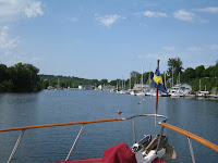
The next day (the 2nd of July) we took our new friend's recommendation and went up the uncharted river to Napanee - a nice adventure we hadn't planned on and a beautiful trip up the small river leading from Desoronto to Napanee. The river had plenty of water (the lest we saw on the depth sounder was 7 feet) and the channel was well-marked with buoys maintained by the Conservation Commission. We stayed on the wall at the town park provided by the Parks and Recreation Department. The charge, with 30 amp electricity, was only $10.00 per night - a real deal! It was a beautiful spot at a quiet park with many picnic tables and shade trees.
As we departed the next morning we decided that we would return on our way back east from Belleville when Rebecca and Alyssa were onboard so they could enjoy the pleasant surroundings of the narrow river and park. We then spent the 3rd and 4th of July in Belleville. Andrew and Avery walked to the train station where they met Rebecca and Alyssa who had flown from Salt Lake City to Toronto, then took a passenger train from Toronto to Belleville. By 1400 on the 4th of July their family was together again and we were discussing plans for the rest of their short stay on Sanderling. Before Andrew and Avery left for the train station, the four of us were interviewed and photographed by a photographer for the local paper who was doing a story about Americans in Canada for the 4th of July. One of the photos (but no story) appeared in the Belleville Intelligencer on July 7th.
When we departed Belleville on the 5th we basically retraced our earlier route back to Kingston, with the exception that we did not stop in Prinyers Cove - the other places we visited were much nicer and had more to offer. When we arrived in Napanee the first day out we were met by the Mayor and the Director of Parks & Recreation along with a couple of reporters and our friend, Kenn, who had encouraged us to visit Napanee in the first place. The Mayor was interested in our trip up the river, why we visited, and what they might be able to do to get more boaters to visit.


We had a great dinner with fresh vegetables and two different kinds of pork tenderloin in the park that evening.
The next day (the 6th of July) we returned to Picton and had a nice berth at the Picton Marina and Park a short walk to the downtown shops; the 7th we departed at 0700 (Andrew and Rebecca were awakened by the bow thruster) and had a beautiful, sunny cruise back to Kingston.
This morning, July 8th, Judy drove Andrew, Rebecca, Alyssa and Avery to Syracuse where they're catching an Amtrak train to New York City around noon, and will then be in Baltimore this evening where their vacation will continue at the Outer Banks of North Carolina.
Judy and I are going to stay in Kingston thru Saturday, July 9th, to do some shopping at the well-stocked grocery store nearby and see some of the local site, and on Sunday will head into the Rideau Canal system heading for Ottawa.
Before I forget mention this - the Canadians we've met on this cruise are about the friendliest people you could ever hope to find, anywhere. They willingly share their knowledge of cruising and places to visit, and are extremely helpful in ways that are difficult to describe. We're really looking forward to the rest of our summer in Canada!
Totals to date: 344H50M - 2275.9SM
Wednesday, June 22, 2011
Thousand Islands, Ontario
June 11, 2011 Liverpool, NY (Onandaga Lake State Marina)
After shopping at a small grocery store about four blocks from the marina, we departed this nice marina at 1140, entered the Erie Canal and headed west for Seneca Falls. This part of the Erie Canal is very rural, with both very modest "campsites" with manufactured homes as well as newer modern homes along the way. We turned into the Cayuga Seneca Canal at 1735 and went through the "mud" lock, and then thru two stair-step locks and into the pool just before Seneca Falls. There were four other boats along the free wall with electricity and water at Seneca Falls, but there was still room for us at the eastern end. We ate dinner aboard that evening, and stayed the next day in order to explore the town and see the Women's Rights Museum.
Trip: 288H 45M - 1903.2SM
June 13, 2011 (Seneca Falls, NY)
We departed at 0900 to head toward Lake Ontario and the main objective of this summer's cruise! We tied up for the night on the west wall (upriver side) of Lock #24 at Baldwinsville. There was an ACE Hardware, Duncan Donuts, and Rite Aid within walking distance so we were able to get a few non-grocery supplies.
We departed the next morning (June 14) at 0930 heading east and entered the Oswego Canal (leading to Lake Ontario) at 1125. We stopped about 1145 for half an hour to take advantage of the free holding tank pumpout at Phoenix, and then continued on to the wall between locks #7 and #8 in the town of Oswego, just before entering Lake Ontario. We ate dinner at a very good Thai restaurant that evening and did some shopping. The next morning we checked the lake and it was rougher than we wanted for our crossing to the St. Lawrence Rive, so stayed another day. Andrew, Avery and Bob toured the fort, and that evening Andrew and Avery took in a movie, while Judy and I found a Cold Stone Creamery!

Trip: 295H 40M - 1937.9SM
June 16, 2011 (Oswego, NY)
After exiting lock #8 we stopped for fuel just before entering Lake Ontario. We were underway by 0825 and crossed the relatively calm Lake Ontario heading north-northeast and into a bay that lead to Sackets Harbor, New York. I was surprised at the lack of commercial vessels - I had expected to see a line of them entering the St. Lawrence Seaway, but there were none in sight and none showed up on my phone's AIS app. We anchored just outside the channel leading into the town, then Avery, Judy and I took the dinghy to the town dock to explore some of the museums and the battlefield (War of 1812). Most of the museums turned out to be closed that day, but we did walk the battlefield, find an ice cream shop, and make dinner reservations at a very nice restaurant "Tin Pan Galley." We then returned to Sanderling where Avery and Andrew went swimming off the boat and we got ready for dinner. The four of us then returned to the dock and went to the restaurant for dinner - dining al fresco with nicely prepared and presented meals.
Trip: 301H 35M - 1980.7SM
June 17-21, 2011 (Sackets Harbor, NY)
We departed at 0850, headed around the headland and into the St. Lawrence Seaway. Again, I was surprised by the lack of ship traffic, but after arriving at Clayton, New York, which sits right off the seaway, we did see (and feel) several commercial freighters pass heading both up and down river. We stayed at the town dock at Cayton for a day in order to explore the town and the Antique Boat Museum - a spectacular collection of early run-abouts, sail boats, and "speed" boats built for racing.
This photo doesn't begin to show all the boats in the multi-building museum.

The next day we headed across the river to Heart Island and Boldt's Castle (Boldt's Castle) where we tied up at the free dock while we explored the castle and grounds. The island was purchased in the early 1900s by a wealthy hotel magnate and the castle was a gift to his wife; unfortunately, his wife died at a relatively early age before the castle was completed; all work stopped at that point and the castle was abandoned and fell into ruin until it was given to a trust which has maintained it since and is undertaking a mamouth restoration project. We took our time walking through the castle and grounds, and after lunch on Sanderling took the pontoon shuttle boat to the boat house (which housed a few of the approximately 60 boats owned by Mr. Boldt, some of the exhibits were on loan from the Antique Boat Museum). The castle did not permit boats to be tied up to the docks overnight, so early in the evening we moved a few hundred yards off the dock, near the boat house, and anchored for the night.


We were underway at 1010 the next morning (Monday, June 20th) and at 1040 crossed the boarder running through the St. Lawrence River into Canada and hoisted the quarantine flag (indicates we had not yet cleared immigration/customs) and then tied to a dock at Rockport, Ontario, and used the free phone to call Canadian Customs and clear in by phone. All that was required was for me to provide information about Sanderling, myself, and the three other passengers; I had our passports with me, but it wasn't necessary to show them to anyone. While we were at the dock we pumped out the holding tanks (not free this time), bought ice, and then were on our way eastward through the small boat channel along the north side of Grenadier Island to Mallorytown Park, operated by the Canadian Park service, where we bought a season pass for the Canadian Parks which permits us to stay without additional charge at any of the Canadian Parks (along the St. Lawrence River as well as all the Canadian Canals). We stayed at Mallorytown Park for one night, and on the 21st cruised 9.7SM around the eastern end of Grenadier Island and west down the main shipping channel to Grenadier Island Central Park.
We met a Canadian couple who had tied up their 32 foot Carver on the "T" head of the series of slips; when it became obvious that Sanderling wouldn't fit any of the remaining slips (we could only get about 1/2 the boat length into the slip), they offered to move their boat into one of the slips so we could take the "T" head where there was plenty of room for Sanderling. As it turned out, they had met another couple we know (who are cruising in a DeFever 40) a few nights earlier and had dinner with them in Ganonoque, Ontario, just a few miles to the west and a town we anticipate visiting in a few days. Small world! Another boat came in last night with a young couple from Montreal who promptly placed a gasoline powered generator on the dock near the land-side and ran a long extension cord from it to their boat; the young man provided us with a sample of some local port produced in a Vinyard near Montreal and showed me some areas of the Rideau Canal to visit on that part of our cruise.
We are staying here for an extra day since it's a beautiful spot, in a small bay protected from the river current, with rest room and picnic facilities in the park. Avery has been rowing the dinghy around the area, Andrew and Avery have been swimming (in the cold water), and this morning Andrew showed Avery how to operate the outboard (Avery already knew how to row the dinghy from his Boy Scout training).
Trip: 312H 10M - 2057.8SM
Photos to follow once we have a WiFi connection.
Friday, June 10, 2011
Lake Onondaga
We arrived at Lake Onondaga a little after noon today and tied up at the Onandaga Lake State Marina about 2 miles south on the east side north of Syracuse which sits at the south end of the lake.
It's a beautiful setting in a well maintained park which runs the length of the lake with bike and walking trails and boat rentals at this well-maintained and friendly little marina.
After spending the night of the 5th at Lock 11, we then travelled about 48 miles to a free dock at Herkimer where we found some excellent locally made corn salsa at a nearby market.
On the 7th we made a short run of 14 miles to a restaurant dock at Utica, where we did a couple of loads of laundry onboard and equalized the batteries, then ate a very nice meal at the restaurant. We were going to walk to an ice cream shop after dinner, but there were some rather unsavory young adults hanging out on the dock near Sanderling and we thought it best not to leave the boat when their intentions were unknown.
On the 8th we found homemade ice cream when we stopped briefly in Sylvan Beach at the free wall, and then continued another 22 miles across Lake Oneida to Brewerton where we tied up at a very nice free dock provided by the New York Canal Corporation. We only had another 18 miles to get to Lake Onondaga, so we stayed at Brewerton for a second night. During the day Judy cleaned the boat to her specs and I changed the engine oil and filters, and before departing this morning I changed both fuel filters on the generator (last night when running the generator the engine had difficulty operating and the symptoms suggested clogged filters).
Andrew and Avery are coming in by train to Syracuse from Salt Lake City and should be here any minute. They will be with us for about three weeks before we're joined by Rebecca and Alyssa for a few days. In the meantime, we're going go be cruising to Seneca Falls and then into Lake Ontario and the 1000 Islands.
Photos: Canal tug with dredging gear, Sanderling at Brewerton, Judy locking, Canada geese family


Sunday, June 5, 2011
Into the Erie Canal
We departed Kingston, New York and the maritime museum on Saturday at 0710 and had our first really nice day on the water since coming up the New Jersey coast. There was little wind and the sun was shining, although the tidal and river current were against us most of the way to Waterford, past Albany and to the Federal Lock at Troy. As we left the Federal Lock we noticed for the first time a bridge that was close to our clearance height (21.3 feet), and when Judy checked the tide board through binoculars we realized that we needed to lower the mast to insure we would clear the bridge (with mast down we only need 15.3 feet for clearance). So Judy drove slowly while Bob assembled the tools and various lines necessary to lower the mast. Once that was done (it only took about five minutes this time) we proceeded under the bridge and took a left off the Hudson River and onto the free wall (the floating docks were full) at Waterford where we spent the night.
Today we departed Waterford at 0830, entered the first lock on the Erie Canal five minutes later, and completed the "stairstep" series of five locks about two and a half hours later. We completed five more locks before ending the day at lock #11 At Amsterdam, New York. We were travelling by ourselves all day, although there was a group of six boats that had departed ahead of us this morning.
We are tied up tonight along the wall of lock #11 on the up-river side along with three other boats that were here when we arrived about 1755. We ate dinner in an Italian restaurant nearby.
We'll depart tomorrow morning at a reasonable time and continue heading west. We hope to make about 45-50 statute miles a day in order to meet Andrew and Avery in Syracuse on the 10th.
Pictures: Waterford dock (2), lock 2 (the first lock), a flood gate raised for us to pass underneath.


Subscribe to:
Posts (Atom)